|
THE BAHÁ'ÍS OF MAGHERAFELT
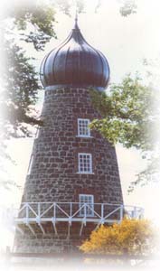
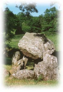
WHERE WE AREMagherafelt lies almost in the geographical centre of Northern Ireland. It has a population a little less than 9,000 and is surrounded by the district of the same name. "Magherafelt" is an Angicization of the Irish "Machaire Fíolta" meaning "plain of Fíolta" - Fiolta being an old Gaelic man's name. The town's foundation dates back to 1425 although it owes its present layout to the Seventeenth Century "Plantation of Ulster". The Magherafelt area covers a swathe of farmland in mid-Ulster, nestling in the shelter of the Sperrin hills (that bisect Northern Ireland) to the west and extending to Lough Neagh, the British Isles’ largest inland lake, to the east. Although transected by main roads it is a gentle place of small market towns and villages, and its fields and meadows readily meet the visitor’s expectation of Ireland’s “forty shades of green” It has interesting historical features. Knockloughrim Windmill standing in a prominent position in the village of the same name. Badly damaged in a storm in the 1890s it was recently restored - a local Bahá’í was involved with the project. Inside there is a circular stairway up to a balcony. This balcony gives you a commanding view of the whole village, the surrounding countryside and Lough Neagh. The Timoney Dolmen, just outside Magherafelt town, is a prehistoric tomb at least 4,000 years old. Dolmens are found in a number of places in Ireland, tomb structures with standing stones and a horizontal capstone.
|